Back
reCursed. - mediated convergence of fragmented views
Skills: Rhino, Grasshopper, Houdini, Illustrator, Photoshop
In a fascinating collision of divergent perspectives, the project brings together divergent perspectives, creating a meeting point where fragmented views find unity through fate. Here, a web of curiosity and connection unfolds, inviting the visitor to traverse a space where conventional boundaries dissolve into a vastness of unexpected encounters. Rather than sticking to conventional lines of sight, the design invites exploration and creates an environment full of unexpected moments waiting to be discovered in built form. The design proposes a space where recursion meets surprise, where familiar elements recur in unexpected ways, leading occupants to pleasant surprises as they navigate the built space.
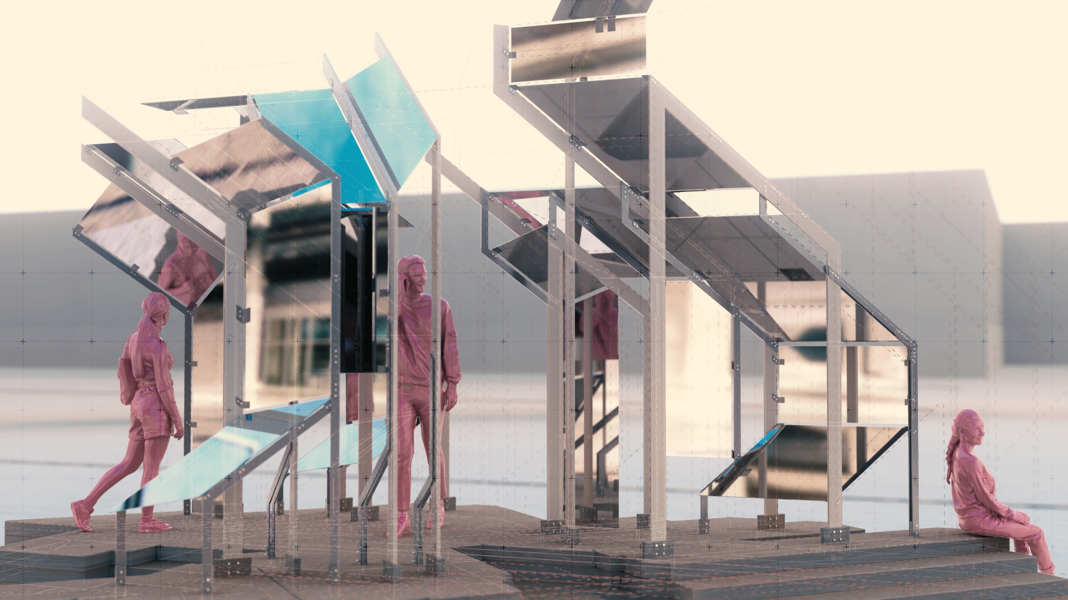
001 - View 01
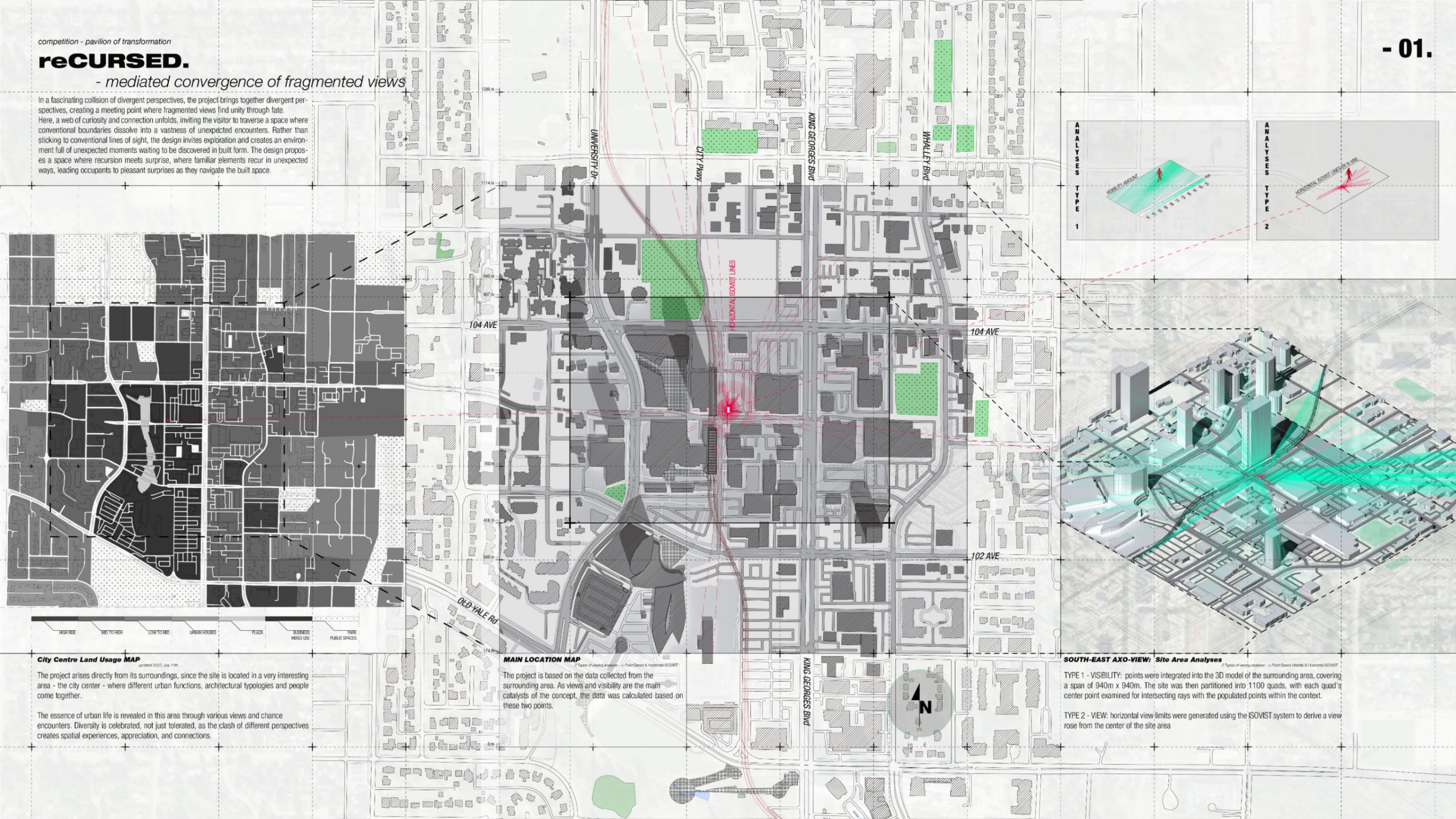
002 - CONCEPT IDEA and ANALYSES
CITY CENTER LAND USAGE: The project arises directly from its surroundings, since the site is located in a very interesting area - the city center - where different urban functions, architectural typologies and people come together. The essence of urban life is revealed in this area through various views and chance encounters. Diversity is celebrated, not just tolerated, as the clash of different perspectives creates spatial experiences, appreciation, and connections. SITE AREA ANALYSES: The project is based on the data collected from the surrounding area. As views and visibility are the main catalysts of the concept, the data was calculated based on these two points. 1 - VISIBILITY: points were integrated into the 3D model of the surrounding area, covering a span of 940m x 940m. The site was then partitioned into 1100 quads, with each quad's center point examined for intersecting rays with the populated points within the context. 2 - VIEW: On the other hand, horizontal views were generated using the ISOVIST system to derive a view rose from the center of the site area
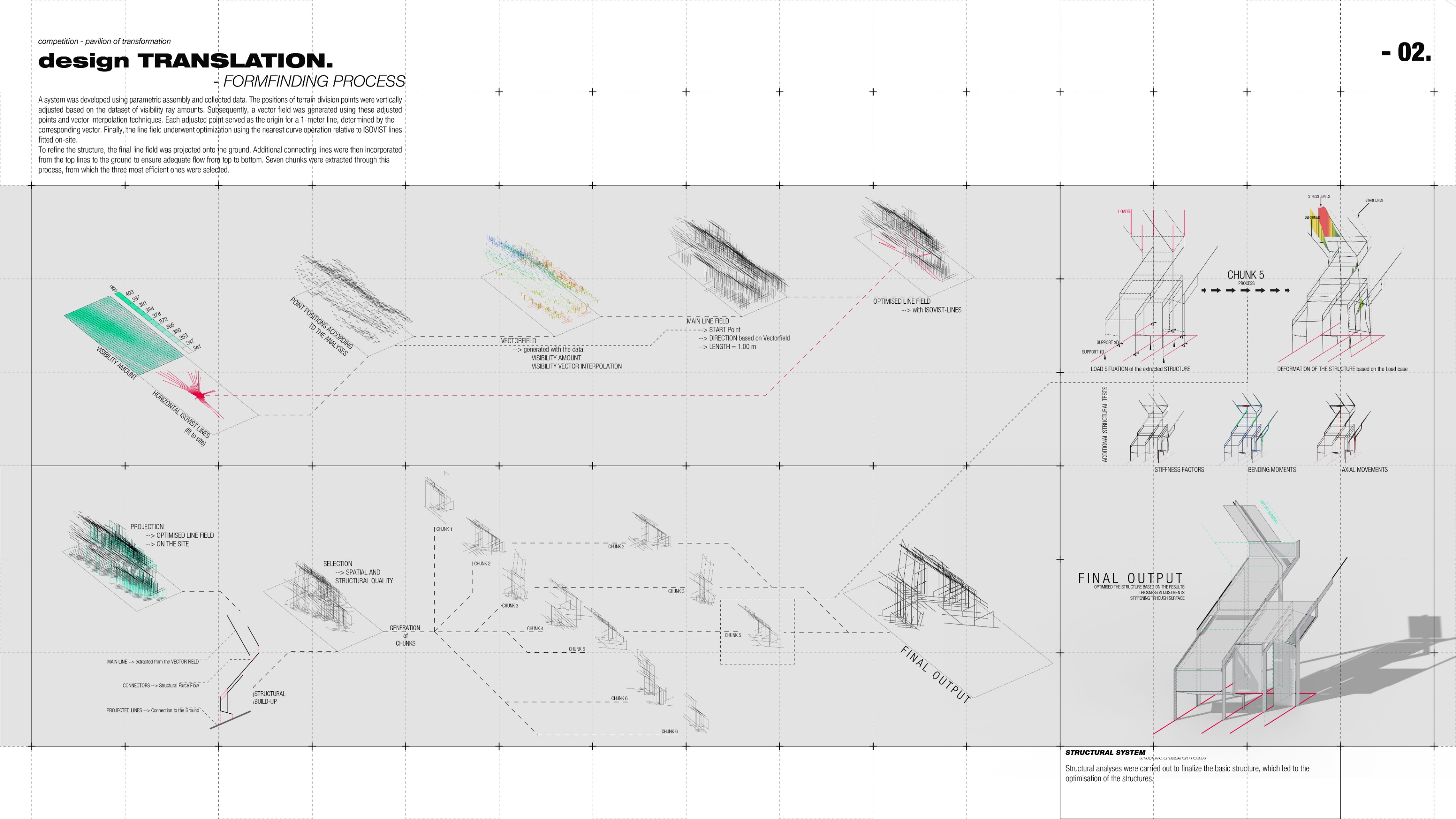
003 - DESIGN TRANSLATION and the STRUCTURAL SYSTEM
DESIGN TRANSLATION and the STRUCTURAL SYSTEM: Utilizing collected data, a system was developed through a series of steps and parametric assembly. The positions of terrain division points were vertically adjusted based on the dataset of visibility ray amounts. Subsequently, a vector field was generated using these adjusted points and vector interpolation techniques. Each adjusted point served as the origin for a 1-meter line, determined by the corresponding vector. Finally, the line field underwent optimization using the nearest curve operation relative to ISOVIST lines fitted on-site. To refine the structure, the final line field was projected onto the ground. Additional connecting lines were then incorporated from the top lines to the ground to ensure adequate flow from top to bottom. Through this process, seven chunks were extracted, from which the three most efficient ones were selected. Finally, structural analyses were carried out to finalize the basic structure, which led to the optimisation of the structures.
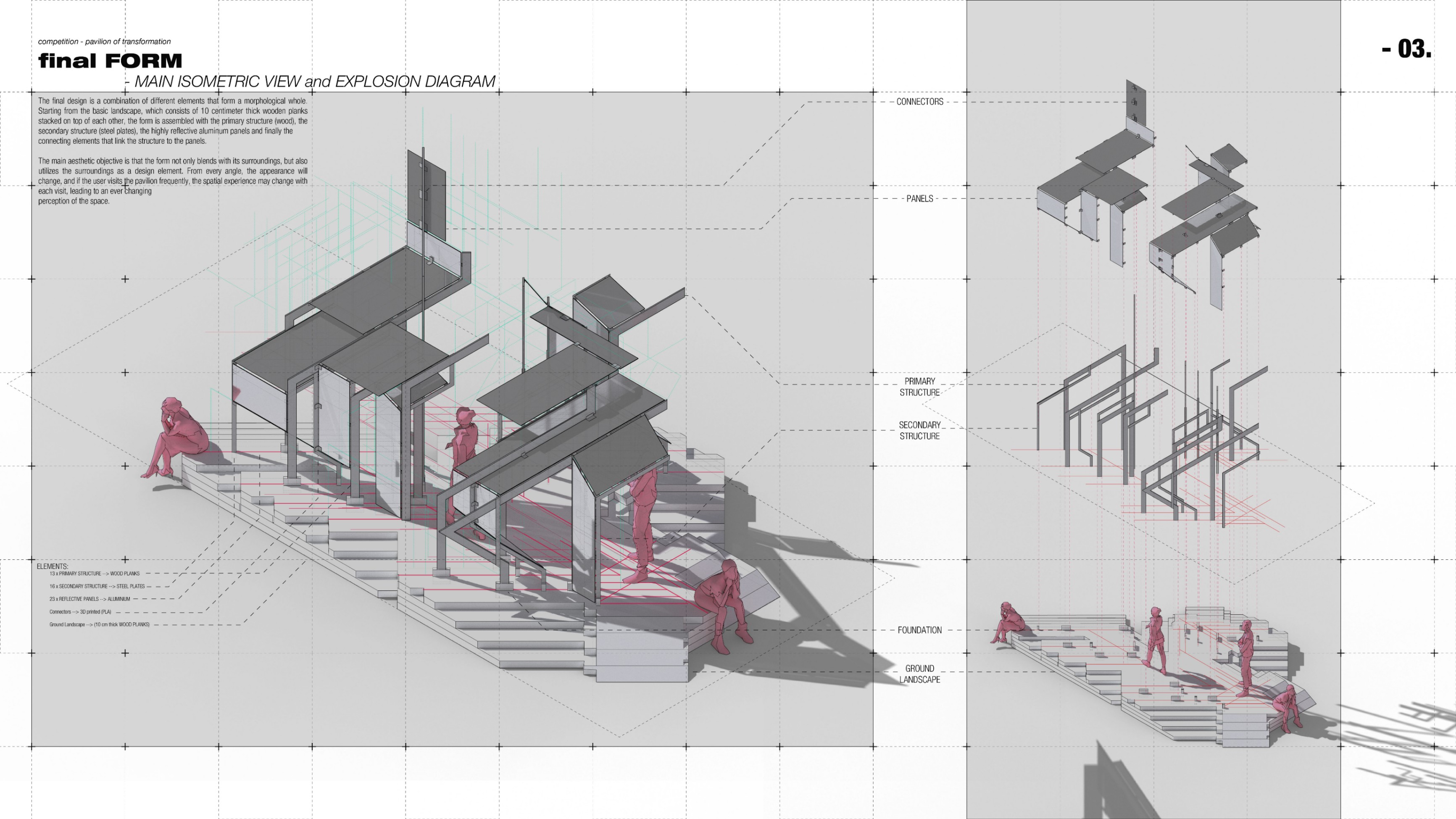
003 - MAIN ISOMETRIC VIEW and EXPLOSION DIAGRAM
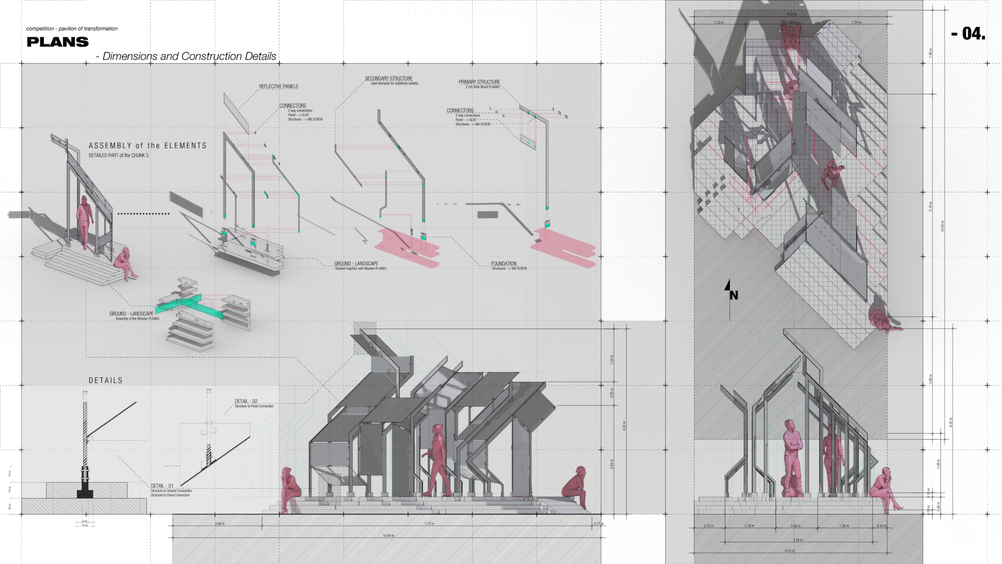
004 - DIMENSIONS and CONSTRUCTION DETAILS
The final design is a combination of different elements that form a morphological whole. Starting from the basic landscape, which consists of 10 centimeter thick wooden planks stacked on top of each other, the form is assembled with the primary structure (wood), the secondary structure (steel plates), the highly reflective aluminum panels and finally the connecting elements that link the structure to the panels. The main aesthetic objective is that the form not only blends with its surroundings, but also utilizes the surroundings as a design element. From every angle, the appearance will change, and if the user visits the pavilion frequently, the spatial experience may change with each visit, leading to an ever changing perception of the space.

Mümün Keser
More by Mümün Keser
View profile